
 Posted by
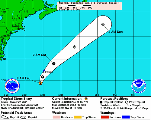
Projected Path of Tropical Storm Shary
Tropical Storm Shary is located at 29.3N 65.7W, which puts it approximately 220 miles to the SSW of Bermuda. Shary currently has maximum sustained winds of 40 miles per hour, making it a minimal tropical storm, and likely will not strengthen too much more before it makes it’s way towards Bermuda. The storm is moving at a rapid 18 miles per hour to the Northwest, however is about to change directions very soon.
The Projected path for Shary, provided by the National Hurricane Center, is one which will take it more in a northerly direction throughout the day today. Sometime this afternoon Shary should be at it’s closest point to Bermuda as it will get. It will then pick up forward speed and by Saturday afternoon already be over 500 miles away from the island. Tropical storm warnings have been issued for the nation of Bermuda, although, the storm likely will not cause much damage, being mainly a rain maker.
There are a couple other areas in the Atlantic basin that need to be monitored. It is possible that we could need to utilize the entire list of names provided for this season’s storms. The next three named storms will be Tomas, Virginie, and Walter.
