
 Posted by
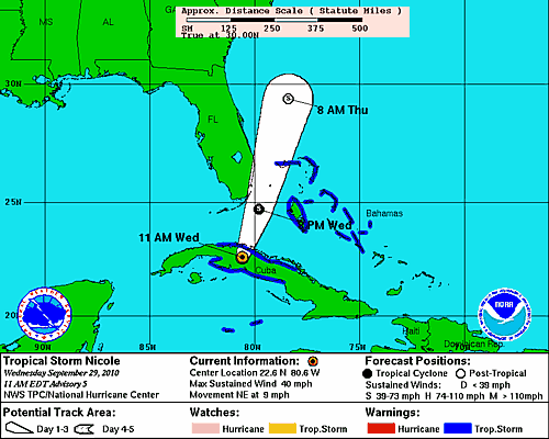
Projected Path of Tropical Storm Nicole
Tropical Storm Nicole was upgraded at 11AM EST by the National Hurricane Center in Miami, Florida. Although the center of the storm is very broad, the NHC has officially located it at 22.6°N 80.6°W, which places Nicole right over the western half of Cuba. The tropical storm is moving northeast at approximately 9 miles per hour, and has maximum sustained winds of 40 miles per hour. The minimum central pressure of the storm is 996 millibars, which is very low for a minimal tropical storm.
The Projected path of Nicole has changed somewhat from only a few hours ago. The center of circulation will likely graze the southeast coast of Florida, probably never making it’s way on shore completely. Having said this, the center is very broad, meaning that nasty weather will likely not be confined only to the center of circulation. By 8 AM tomorrow, Nicole will likely become extratropical, somewhere off the coast of Northern Florida. Extratropical cyclones are usually characterized by having neither tropical nor polar attributes, and are usually connected to fronts. The system will then move up the eastern seaboard, producing heavy rain, and flash flooding throughout a large portion of the East Coast of the United States. Up to a foot of rain could fall in parts of Southeast Florida as well as the Carolina’s and Virginia as the system progresses up the coast.
Tropical storm warnings have been issued by the NHC for a large portion of the Bahama’s, as most of the bad weather is to the east of the center of circulation. Tropical storm warnings and watches have been dropped for all of Florida as the projected path of the storm has been adjusted further to the east. Rain and flash flooding, rather than wind, will be the major concern throughout the day, today and tomorrow, for much of the East Coast.
