
 Posted by
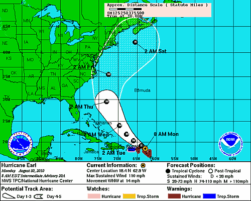
The Projected Path of Hurricane Earl as of 8 AM
Late tonight and early tomorrow morning, the storm should pass about 50-100 miles north of Puerto Rico. It will then slowly move in a northwest direction for the next 2-3 days, getting fairly close to the shores of North Carolina by Late Thursday night. By Friday evening or early Saturday morning, Hurricane Earl should be off the coast of Cape Cod. Right now, the NHC cone of error has parts of North Carolina, Virginia, Maryland, Delaware, New York, New Jersey, Rhode Island, Connecticut, New Hampshire, Massachusetts and Maine all in it. This means that according to computer model forecasts, the storm could directly impact these areas. Having said this, the official projected path that the NHC is putting out would have Earl missing the US East Coast by about 100-150 miles. All interests on the East Coast should pay attention over the next few days.
